

Welcome Re/Cappers!
Today features quite the deep sea dive, full of autonomous underwater vehicles and an extraordinary capture. But what makes it worthy of a six-part docuseries as opposed to some meager reality capture newsletter highlight, is the sheer scope of its overarching mission.
Since the United States entered World War II, 52 U.S. submarines embroiled in conflict have been lost. But Tim Taylor, an accomplished oceanographer and technologist, knew there was a sliver of hope for their discovery.
He had developed a proprietary photogrammetry methodology, which helped transmute a radical idea into a groundbreaking 24-minute documentary, Expedition R-12: America's Forgotten Submarine. A poignant tribute to the USS R-12 sub and her crew alike, it would become the genesis for one of the most ambitious reality capture projects on the planet - The Lost 52 Project.

The Lost 52 Project CEO Tim Taylor, as his undersea drones trek to the USS Grayback. Image credit The Washington Post/Tim Taylor
And now, almost unthinkably given the expanse of the ocean, Tim & team are into the double digits of sub discoveries, turning mystery into remembrance and the missing into the honored.
Thankfully, Tim himself is a recipient of honor, having earned the U.S. Navy’s Distinguished Public Service Medal, alongside a number of other intercontinental decorations. Best of all, Tim, his maritime maestros, and his depth-diving drones show no sign of slowing down.
Details on their latest odyssey, coming right up.
What’s Cappenin’ This Week: WWII submarines get modeled and honored, crops get modeled & printed, North Africa gets giddy for public health GIS mapping, smart cities get ranked, and the U.K. gets a gusty day for an AEC Error of the Week.
Last week on an Alabama civil rights landmark getting documented, BIM & digital twins tag teaming for sustainability, an AI legend updating predictions on stage while wearing sick suspenders, Porsche bringing a positive charge to battery tech, and an AEC Error of the Week in Minneapolis, Minnesota that sparked nationwide maintenance.
The USS Harder received six battle stars in World War II, garnering the nickname “Hit ‘em Harder” for her pugilistic ways in the process.
Some 70 years later, perhaps a seventh is in order; this time for the crew that found her.

Model of the USS Harder, derived from the photogrammetry of the Lost 52 Project. Image credit Naval History and Heritage Command
The Lost 52 Project has claimed another victory in its quest to locate, capture, and model all 52 U.S. subs lost since the Second World War. Read the full account below, spanning the Harder’s location, insights gleaned, and the awards already bestowed to the Lost 52 Project. Get the deeper dive on methodology and context here.
Metrology, meet plant-ology!
Plant phenotyping = measuring the functional and structural parts of plants. Long hindered by the tedium of manual measurements, it has now become more automated and detailed thanks to LiDAR, machine learning, 3D modeling and 3D printing.
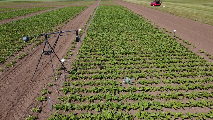
One of these things is not like the others. Image credit Institute of Sugar Beet Research, Göttingen
The real endgame, beyond mere research? Augmented plant breeding and more robust, abundant crop yields. SeedWorld tells the whole story below of how one Jonas Bömer and his team of imaginative colleagues may have ignited industry-wide change with some sugar beets, a scanner, and a 3D printer.
The Africa CDC recently hosted seven North African countries with the hopes of encouraging GIS mapping adoption for public health. And Tunisia was tuned in like a Sahara jogger would be to a distant oasis.

The dapper mappers of Africa CDC, seen here at the GIS summit for North Africa. Image credit Africa CDC
Specifically, the gold at the end of this mapping rainbow = visual representations of laboratory capabilities, statuses, and capacities. Better yet, Africa CDC is primed for success in North Africa, as it already has 18 mapping reps with other member states across the continent. Get the GIS gist below.
…Which is that Switzerland is apparently the equivalent of Einstein, plus that guy who won Jeopardy! for like three months straight, multiplied by ChatGPT v27.

Some sources project that a smart government should be attainable by the year 4038. Image credit TechTarget
Because they just landed three of their cities in the top 10 of a smart cities ranking project. Drawn from a combination of hard data and survey responses, the initiative was a co-creation by the Smart City Observatory and World Smart Sustainable Cities Organization. Get the rankings below, with lists dedicated to Europe, the United States, and the globe itself.

The Bridgewater Place skyscraper in Leeds, West Yorkshire, England. Image credit Architects’ Journal
Ever heard of a building that gives complimentary flying lessons? Meet Bridgewater Place in Leeds, UK - the skyscraper that decided to double as the world's largest hair dryer.
Completed in 2007, this 32-story giant quickly went from a cool breeze of an idea to a tempest of turmoil.
Thanks to downwash, it created winds so strong at its base that it turned simple strolls into X Games entries. Why? ‘Twas built right at a major intersection; because nothing says "urban planning" like a vortex of chaos at a busy junction.
Now, predicting or even planning for wind patterns in urban environments is trickier than taking a tea party in Boston seriously. But here's the kicker - we have the technology! Reality capture and digital twin tech could have saved Leeds from becoming the UK's unofficial wind surfing capital.
See, the initial wind assessment conducted for the planning application suggested the building would have minimal impact on wind speeds. However, this proved to be inaccurate once construction was completed, because what informed it was inaccurate.
If only a technology existed that improved accuracy…
You know, like high-precision LiDAR and photogrammetry, forging an accurate 3D model of the site and surrounding area. A digital twin, combined with computational fluid dynamics (CFD) simulations, allowing the prediction and visualization of wind patterns around the proposed building under various conditions. Design iterations being rapidly tested virtually, optimizing the building's shape to minimize dangerous wind effects at street level.
Mid-construction, regular use of LiDAR or photogrammetry could have ensured the as-built structure matched the wind-optimized design. Real-time wind measurements could have been compared against simulations, allowing for potential adjustments.
And voilà, instead of spending boatloads on post-construction "fixes" like barriers, canopies, and actual wings (talk about a flying buttress), issues would have been nipped in the bud.
Remember, in AEC, it's always better to capture reality before reality captures you in its wind-tunnel death grip. Stay grounded peeps.


By subscribing, you are agreeing to RCN’s Terms and Conditions of Use. To learn how RCN collects, uses, shares, and protects your personal data, please see RCN’s Privacy Policy.
Reality Capture Network • Copyright 2025 • All rights reserved


