


Get James Cameron on the blower Re/Cappers, you got a Titanic lead story coming your way on the capture and twinning of 1912’s Queen of the Ocean.
This accomplishment sits in an echelon of one. It looks like Celine Dion sounds. But don’t think for a second that shipwreck scanning and mapping haven’t experienced extraordinary feats. In fact, one was at a time when to 99% of folks, “scanning” meant ringing up groceries, and “robots” meant I, Will Smith movie.
As in 2004, when Greek researchers were seafaring across the Aegean. They were employing side-scan sonar as a part of a vast survey in the Chios Strait when they discovered a 4th-century BCE merchant shipwreck. The Hellenic Centre for Marine Research (HCMR) confirmed the site’s archaeological significance, thanks to their Super Achilles ROV (remote operated vehicle, definitely didn’t have a heel).
The excitement was just beginning because the ideas were brewing. What if we could employ this burgeoning innovation known as autonomous underwater vehicles (AUVs), to map, capture, and reconstruct this Mediterranean time capsule?
The researchers pinged the Woods Hole Oceanographic Institution (WHOI) to propose a collaborative survey using WHOI’s SeaBed AUV, which had recently demonstrated success in deep-sea imaging. By ‘05, an MIT/WHOI-led team deployed it. Over four missions, the AUV scanned the site and its bounty of cargo, forging a topographical map while capturing 7,000+ overlapping images. These would be stitched into a 1cm/pixel photomosaic that documented 350+ amphoras (big ol’ ancient jars) and hull fragments. Antiques Watershow anyone?
It was a red-letter day for underwater survey & mapping, shipwreck photogrammetry, 3D reconstruction, autonomy, sonar technology, and archaeology. It illustrated that what would take divers months if not years, could take AUVs days.
There’s a 2006 quote from the excursion’s co-pilot, Brendan Foley, of the WHOI - “We’re not looking for footnotes any more. We’re looking to write new chapters, and are convinced that in 10 to 15 years using these methods, we will have changed history.”
Can, a human, be more prescient?!
More shipwreck history changing coming right up. But first, know the image below is months away from being able to buy beer.

A portion of the 2005 photomosaic over the multibeam bathymetry. Image credit WHOL Hellenic Centre for Marine Research, Hellenic Ministry of Culture: Ephorate of Underwater Antiquities
What’s Cappenin’ This Week
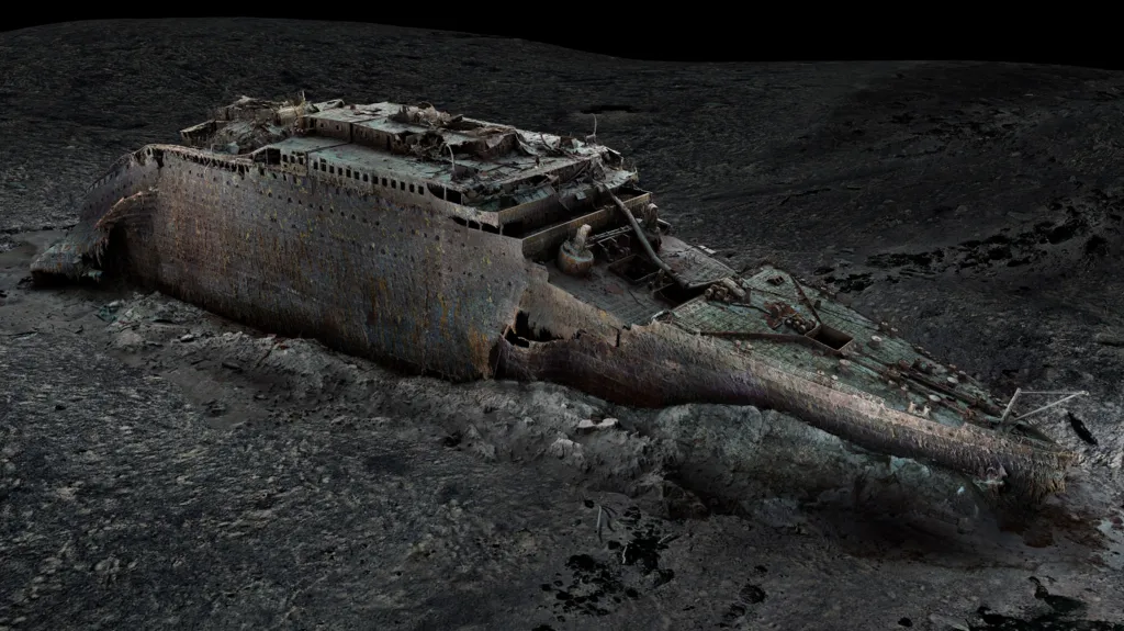
For determining what exactly happened during the “unsinkable” ship’s demise, hindsight isn’t just 20/20. It’s twinny-twinny!
And get the popcorn ready, because the revelation is all courtesy of a new National Geographic doc, Titanic: The Digital Resurrection, in partnership with Atlantic Productions and deep-sea mappers Magellan.
A portion of the 2005 photomosaic over the multibeam bathymetry. Image credit WHOL Hellenic Centre for Marine Research, Hellenic Ministry of Culture: Ephorate of Underwater Antiquities
Plunged 3,800 meters deep in the Atlantic abyss, underwater robots scoured the legendary wreckage, capturing its remains from every conceivable angle. This yielded a trove of over 700,000 images, fused to create a digital twin that resurrects the Titanic's form in breathtaking detail.
Highlights: the moment when the vessel violently tore apart during its 1912 descent to the ocean floor, claiming 1,500 lives in the aftermath of the iceberg collision. Stunning detail unveils the boiler room where heroic engineers sacrificed themselves to maintain power until the final moments - a discovery that validates survivor testimonies. Meanwhile, simulations suggest a startling revelation: the mighty vessel's fate was sealed by hull breaches no larger than sheets of paper.
Get BBC’s lowdown, literally, touching on stern damage, mapping technologies, new timelines of the disaster, numerical algorithms and simulation workflows, and how long experts will need to analyze the twin in its entirety.
Though debate may continue over whether Moore’s Law is stalling in two dimensions, it sure is thriving in three. While traditional imaging was leisurely in its 2D evolution, the pace of progress in 3D reality capture feels less like iteration and more like a phase change.
This is the nucleus of a half-advocacy, half-case study piece from Michael Rubloff, Managing Editor of the esteemed Radiance Fields repository. It explores where we go from here - and why the concept of “capturing reality” is being redefined in real time. Better yet, it spawned from an experience Rubloff anointed “The Best Dynamic Gaussian Splatting in the World”.

Supplement the video above with the article below, which navigates Rubloff’s trek to the UK countryside for a total shooting experience at Infinite Realities headquarters: 176 cameras, 484 lights, every wasted second equaling 127 wasted gigabytes, 300,000 still images, and infinite potential if Infinite Realities is any indicator.
Wind energy is a solid…hedge. Its turbines can go where solar panels can’t, and can produce on cloudy days when the sun’s rays take a raincheck. It evades the danger stigma of nuclear. And hydrogen, well…it’s like the MySpace of clean energy; big promise, a few early fans, but a lotta silence.
Unfortunately, though, there’s one massive wind energy downside that has experts racking their brains - effects on life under water, and birds above it. And while progress is being made on the former, a partnership for the latter is spreading the wings of avian safety, environmental monitoring, and renewable energy.

Fugro’s SEAWATCH wind LiDAR buoy. Image credit Fugro via Tomorrow’s World Today
The futuristic flock consists of Geo-data dynamos Fugro, and intelligent biodiversity monitoring maestros Spoor. Their stated goals include “helping renewable energy projects reduce environmental impact, develop a new AI bird monitoring system for offshore renewable energy projects, and make environmental assessments more affordable, cleaner, and safer.”
The hero in this story is Fugro’s SEAWATCH Wind LiDAR Buoys, which record bird activity on wind farms. Spoor’s computer vision and AI software then take the reins for species and activity analysis. It’s a tidal wave of efficiency, disposing of the burdens within traditional methods of offshore bird monitoring and legally-mandated environmental assessments: costly aircraft & vessel requirements, high carbon footprint, and storms that would have Lieutenant Dan screaming from a mast.
Tomorrow’s World Today covers the wind win below, including test sites, biodiversity requirements, the buoy-mounted cameras, and more.
The construction industry = noir detective novel. Oh, the woes of the jobsite, a gritty cityscape overrun with mysteries to solve: delays, inefficiencies, safety risks. The cacophony of machinery suppressing innovative thought. And Dave over there has been on a MARATHON smoke break. What’s he up to?
This renders AI as the hardboiled private eye, armed with pioneering tools to uncover the truth - and get subs paid! Companies from $360-billion juggernauts to scrappy startups are implementing it, to get just the facts ma’am. And according to Construction Dive, four recent implementations are craning above the crowd.

A slice of Earthcam’s Control Center 9. Image credit Earthcam via Yahoo! Finance
The recent publication first explores a global powerhouse augmenting payment management for subs, mostly through Turing-test-passable interaction and monitoring. Then comes a project tracking technique that prevents bottlenecks like MADD prevents bottles.
After that, be stunned by an autonomous drywall-painting robot that harnesses AI, 3D scanning, and real-time modeling. Last but not least is a construction management monitoring software that, thanks largely to 360° cameras, is to jobsite health what handwashing was to human health. Break ground on Construction Dive’s analysis below that proves artificial is getting very real.

The brick chipping of UMass Amherst’s W.E.B. Du Bois Library. Image credit Joe Cohen via UMass Amherst
At this library, you don’t just keep it down - you surely better look up!
The W.E.B. Du Bois Library at the University of Massachusetts Amherst, completed in 1973, was designed to be an architectural centerpiece for the rapidly expanding campus. At 28 stories and 286 feet tall, it remains one of the tallest academic libraries in the world - and was once the library height king. However, its striking brick facade quickly became infamous for a structural issue that plagued the building for decades: spalling, where pieces of brick chipped off and fell from the exterior. This led to safety concerns, long-term mitigation efforts, and a chance to experience Newtonian physics outside the library rather than just read about it inside.
It was due to improper attachment methods. The bricks were part of a veneer added late in the design process when planners opted for brick over limestone to save costs. The latter would also have required removing several floors from the building. The issue stemmed from how the bricks were attached at relieving angles along the facade. Narrow mortar joints made these areas vulnerable to damage from freeze-thaw cycles, causing pieces of brick to chip away over time.
By 1979, the problem had escalated enough that the university closed the library for an entire semester - the only known instance of a building taking a sabbatical. Temporary measures included hay bales to isolate spalling zones - an ironic nod to UMass’s agricultural roots - before replacing them with a chain-link fence that remained for over 30 years. Although no full bricks ever fell, urban legends persisted about bricks hitting students on the ground.
In 1983, UMass secured $2.5 million from the state legislature to address the issue. Renovations focused on repairing the brick veneer and reconstructing parts of the building’s lobby and lower floors. While these efforts restored full usage by 1985, spalling continued sporadically into the 21st century, prompting further safety measures and eventually replacing the chain-link fence with a more permanent barrier in 2011.
Despite these challenges, the library remains an iconic structure on campus, offering spectacular views and serving as a hub for research and study; however, its facade failure highlights critical lessons.
The W.E.B. Du Bois Library saga isn't just another brick in the wall of architectural mishaps - it's a towering testament to what happens when gravity decides to critique your design choices. Had modern reality capture technologies been available, this academic tower of terror might have avoided its reputation as UMass Amherst's most dangerous game of to-be-concussed-or-not-to-be-concussed.
Modern reality capture would have armed architects with an arsenal of brick-saving interventions: high-resolution laser scans creating "mortar-fying" maps of every vulnerable joint before the first brick contemplated its daring escape; thermal imaging exposing freeze-thaw conspiracies in glorious technicolor, revealing the hot-and-cold relationship between Massachusetts winters and structural integrity; drone photogrammetry tracking facade degradation with the obsessive detail of a helicopter parent, eliminating the annual "Look out below!" season; and comprehensive Building Information Models simulating environmental impacts during design, prompting that uncomfortable conversation no architect wants to have: "Listen, I know you love the aesthetic, but these bricks have commitment issues stronger than your average dating app user."
UMass-Amherst learned the hard way that cutting corners on analysis leads to cutting off access to sidewalks. Reality capture technologies offer more than just pretty 3D models - they're the architectural equivalent of preventative medicine, exposing vulnerabilities before they become safety hazards and campus legends.


By subscribing, you are agreeing to RCN’s Terms and Conditions of Use. To learn how RCN collects, uses, shares, and protects your personal data, please see RCN’s Privacy Policy.
Reality Capture Network • Copyright 2025 • All rights reserved


