


Banana up and get limber Re/Cappers. We’re monkeying around in the canopy today thanks to a rainforest-LiDAR-NASA development.
The rapport between LiDAR & rainforests isn’t revelatory to even the most casual ‘cappers; the past 3-5 years have been rich with LiDAR-led discoveries and hypotheses in and around the globe’s rainforests. Was that the start?
Nowhere near it.Steel magnate Andrew Carnegie kindasorta gave us libraries. He also gave us the Carnegie Institution for Science, which gave us the employment of scientist Greg Asner, who in 2006 gave us the Carnegie Airborne Observatory. The CAO’s signature computing package was, and still is, called AToMS, or Airborne Taxonomic Mapping System.
Rainforest research would never look back.
It wasn’t just the jaw-dropping efficiency of the capture or modeling, but what could be gleaned from it.

We’re talking novel species information. Biomass data and chemical makeup insights. Watershed and waterway analysis. OH, and carbon storage – the very same objective NASA just set its sights on, that we’ll cover shortly. Asner may have been ahead of the curve. But if rainforests can be preserved, it’s a straight line back to him.
Asner’s 2013 TED Talk – “Ecology from the Air”
What’s Cappenin’ This Week: Rainforests scanned from the stars, AI mining looms large, European Infrastructure dines at a reality capture buffet, digital twins turn supply chains from loosey-goosey to iron-clad, and a Las Vegas AEC Error of the Week, where the MGM Grand was once the MGM Damn.
Last week on a court holding court on drones & surveying, orthopedic surgeons getting 3D & AR empowerment, NASA looking to digital twins for wildfires, 3D software & beginner drones getting 2024 rankings, and an AEC Error of the Week with so much gridlock in the nation’s capital, it makes the U.S. Congress look like SEAL Team Six.
Yes, it’s actually pronounced “Jeh-dye”, yes it’s a device that shoots laser beams from the bloody International Space Station, and yes, we now hold precious data on the Amazon, the Andes, and Patagonia.
And ain’t nothin’ science-fiction about it.

The Global Ecosystem Dynamics Investigation has just been extended by NASA, meaning for at least six more years, this laser blazin’ cosmic canopy capturer can keep getting researchers the stored carbon data of millions of trees. How exactly? Let ScienceFriday tell ya, along with bonus abilities GERD possesses as it shines a light on the dark side of natural disasters.
The mining industry employs 1% of the global workforce, yet produces 8% of all fatal accidents. So while many of us are basking in AI recipe generation and LLM Tinder, the current tech revolution can be a bona fide life saver for one of the most unsung professions on the globe.

But safety is only the tip of the mine shaft, as Innovation News Network recently detailed. Drill down on mining’s AI-fueled future in data capture & drone exploration, processing geological surveys, sustainability, predictive maintenance, and more.
Know what bears and the European Commission now have in common? They’re both great at monitoring things: bears their cubs, the EC their infrastructure.

It’s all thanks to the REALTIME3D UAV system, launched by the EPCIP (European Programme for Critical Infrastructure Protection) which was launched by the EC. It’s been a heck of an evolution, en route to augmenting infrastructure inspections like few technologies before it. GIM International details the tech, the process, the agencies and the future below.
Ask a friend for five things they remember about the infant months of the pandemic, and your odds of hearing “toilet paper shortage” are higher than someone talking while muted while still learning Zoom in 2020.

Sure, panic buying was a factor. But so were supply chain issues that persisted well past the peak of the dreaded TP variant. Shipping and logistics titan Maersk knows it, and more importantly, they know how to craft a supply chain impervious to any demand spike – digital twins. Read their vision of supply chain planning, warehouse & transportation management, challenges, and scalability, all tied our beloved digital duplicates.
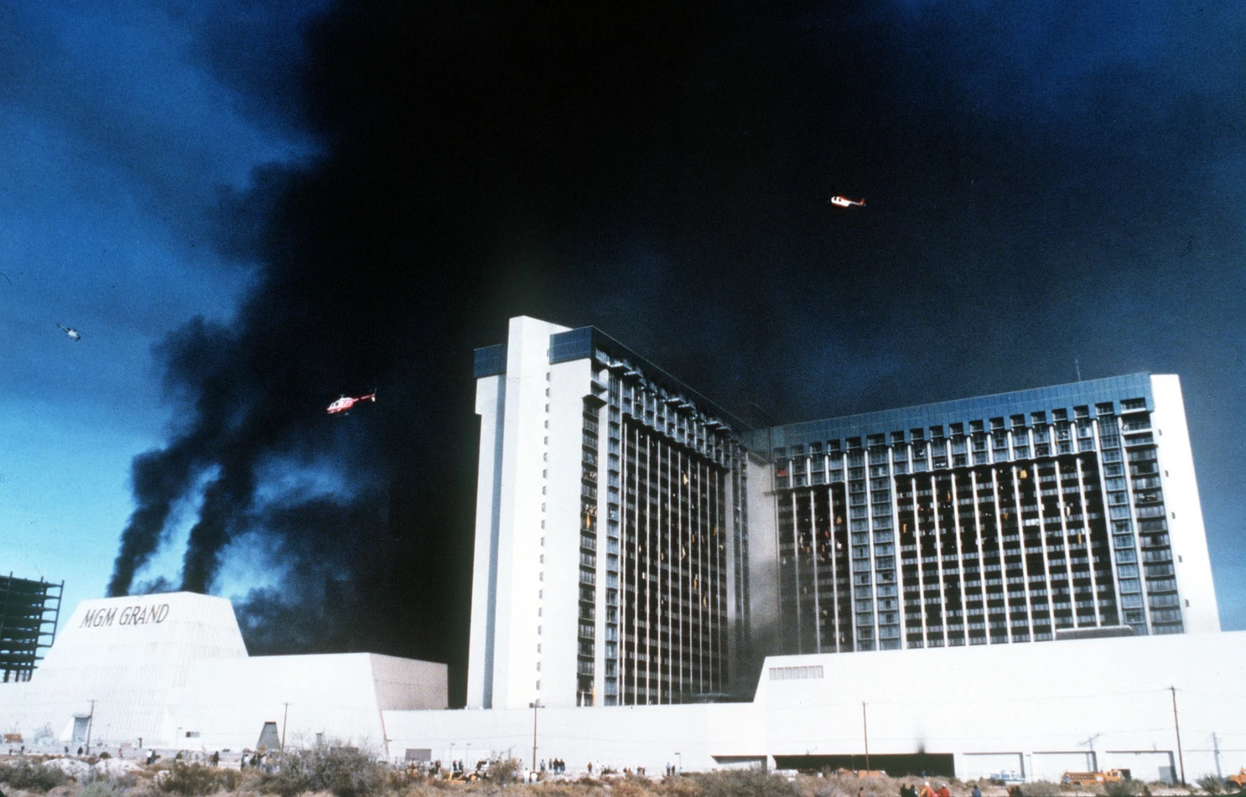
In Sin City, perhaps the costliest one is skimping on MEP.
On November 21, 1980, a minor electrical fire in a restaurant pantry at the MGM Grand Hotel and Casino rapidly escalated into one of America’s most horrific high-rise blazes.
And it just as rapidly descended into controversy.
The principal cause was faulty electrical wiring, although a litany of problems from deficient HVAC and nonexistent sprinklers, to excessive flammable material, only fanned the flames.
While the fire’s origin and rapid spread exposed rampant AEC blunders, the extent of loss was ultimately a wake-up call on regulations and best practices. The negligence and corner-cutting, by so many project stakeholders, was so egregious that 1,327 lawsuits would follow. And probably just as many lessons.
Chief among them, as cited in that last link, is adoption of new technology. It was avoided then, and is still routinely avoided now.
Today’s reality capture, BIM, digital twin, and VR technologies would have surely attenuated this catastrophe, if not prevented it outright. Verifying fire code adherence and proper implementation of electrical systems and wiring, through reality capture? All too feasible.
3D BIM models integrated with materials data could enable simulations analyzing how fire could spread based on the actual constructed conditions. This same digital twin containing up-to-date MEP, fire protection, and egress data could allow first responders to analyze best response tactics tailored to that specific building. Oh, not to mention, VR fast establishing itself as a firefighter training fixture.
So perhaps it’s time to make technology a built environment fixture.


By subscribing, you are agreeing to RCN’s Terms and Conditions of Use. To learn how RCN collects, uses, shares, and protects your personal data, please see RCN’s Privacy Policy.
Reality Capture Network • Copyright 2025 • All rights reserved


