


In the (eerily prescient) 2013 film Her, ScarJo’s AI character, Samantha, muses “The past is just a story we tell ourselves.”
Bro, do you even Re/Cap?
The past (winter) wasn’t some manufactured story; it was a Himalayan avalanche of innovation. Laser scanning, photogrammetry, robotics, BIM/VDC, survey, AI, drones, XR, metrology, GIS, radiance fields, and digital twins have seen landmark developments these last few months.
But even the best of us miss things. And some stories? They deserve a second look. So Re/Cap HQ thought it best to, before mothballing those parkas, recap some premier Re/Caps. You read right, it’s time for a hibernal edition of the:

Due up are innovation’s crown jewels of the past five months: intrepid experiments, genius integrations, juicy predictions, arduous inventions, and tactful partnerships. As a cherry on top, you can enjoy a “Top 5” AEC Errors of the Week – blunders that reality capture could have surely mitigated or prevented outright.
So without further ado, enjoy a Wintry Best of the Re/Cap, and thanks for your best in producing a better built world.
TIME magazine has been annually ranking our world’s best inventions for 23 years, refining their industries and selection process over the same period. The criteria for 2024 boiled down to originality, efficacy, ambition, and impact.
That’s right up Re/Cappers’ alleys, even if every listing isn’t bona fide reality capture.

Whadda we got? Humanoid robots entering the workforce, autonomous crop drones, 3D modeling & printing, 360° action cams, car scans, the world’s largest computer chip, oh, and by the way, a 3D map of some dainty entity known as our universe. And all that’s hardly the appetizer round, so good luck spending under 200 minutes in this 200-item portfolio of technological splendor.
From Tinder photos to gas station jerky tolerance, dental implants are a modern marvel. But they are far from perfect, what with tedious creation processes, inaccuracies, unpredictability, maintenance, and poor procedure explanation to patients.
Well, AI & photogrammetry are about to bring as much relief as the first floss after a ten-year hiatus.
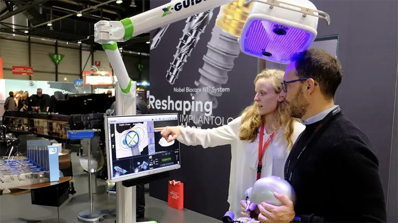
Nobel Biocare has just unveiled FastMap, which allows dental professionals to measure and maintain the true position of implants and abutments relative to the preoperative prosthetic plan and the patient’s anatomy. Ever-conveniently, the X-Guide device hovers over the patient, abandoning any need for handheld devices. Bite down below for Dental Tribune’s breakdown on the process, capabilities, modeling, and more.
Jurong Port is Singapore’s lone multipurpose one, processing general, containerized, and bulk cargo. The latter kind is often the most elaborate, as it can’t be automated the way the former two can be, and requires focused, agile, hands-on crews.
For decades, that’s been the story at Jurong. But a new character just entered. Its name is JP Glass, it’s a digital twin, and it’s bringing a shipload of data.

Relying on GIS like Captain Phillips relied on those snipers, JP glass is a hub of hubs. Displayed ‘round-the-clock at Jurong Port’s General Cargo Office, it gives a pristine view of operations, detailing incoming cargo, what equipment is needed, available personnel, storage capacity, weather, port traffic, even vessel berth depth.
But just as fascinating as what the twin is doing, is why it became necessary. Climb aboard Esri’s blog below for the port’s history and future expansion, with ample tech talk throughout.
Today, only 3% of humans live at or above an elevation of 6,562 feet, which is where an extraordinary discovery was just made thanks to aerial LiDAR: two Silk Road strongholds, lost for centuries, nestled in the mountains of Uzbekistan.

Overseeing the project is Michael Frachetti, a professor of archaeology at the Spatial Analysis, Interpretation and Exploration laboratory at Washington University in St. Louis. Discovering hints of settlements, watchtowers, fortresses, and plazas, the operation is entering the excavation phase quicker than you can say “haggle.”
And the crew is not there to just collect some wares for a shot at Antiques Roadshow, oh no. They’re after who founded these mysterious cities, and why. CNN Science ran with the gripping story linked below, but you can also get academic and take in the paper proper, hosted on Nature.
The labor shortage in construction is dire, even in spite of the field’s record spending. The aging workforce trading hands on the shovel for toes in the sand is a significant cause. But it’s matched by a failure to lure new talent, particularly women since, you know, they’re half the population for Pete’s Pam’s sake.

This dearth prompted the U.S. Department of Commerce to author the “Million Women in Construction Community Pledge” in May of 2024. It also prompted Maria Davidson, CEO and founder of ConTech company Kojo, to pen a discerning piece on how exactly such a lofty vision could materialize. Enjoy a trove of wisdom below on targeted campaigns, educational institutions, training, work environments, and much more, thanks to For Construction Pros.
Loneliness is a global epidemic. Worse yet, its effects are more pronounced for, and more common among, the blind and visually impaired. And what tends to increase as more people continue living longer? Loneliness, and vision loss.
Tactile maps have mitigated these difficulties, but their problem lies in their tedious, often prolonged creation. And that’s precisely what technology, and some inspiring testers, are solving.

Four organizations – Kadaster, Foundation Accessibility, Dedicon Foundation, and Esri – are collectively developing advanced tactile mapping technology. American Surveyor profiled the uplifting story through the lens of Ellen Zieleman, a 60-year-old woman who became fully blind five years ago, yet has achieved newfound independence through tactile maps. Click below for some geospatial feel-good.
Modern optical metrology is precision’s architect…except the light beams have subbed in for pencils.
The shape, surface traits, dimensions, and physical properties of objects and materials can be defined in ways that, centuries ago, would be deemed occult-ish. It’s created seismic change in a many an industry, from electronics and healthcare to manufacturing.

But knowing where you’re going is aided by knowing where you’ve come from, which is why AZO Optics’ recent publication – part history lesson, part prognostication – is so beneficial. With almost a section per century, it encompasses the entire arc of metrology, closing with astute coverage of recent developments and future possibilities. Set your sights on sensors, lasers, semiconductors, automation & machine learning, data storage, and a whole glasses case more, below.
Earlier this year at Beijing’s DEEP-2024 symposium, the China Geological Survey gave the world quite the preview. And now that we know its finer details, the project itself may be a preview of new eras in survey, energy, resource management, and the comprehension of our own land’s subterranean history.

The geological odyssey known as SinoProbe II will begin its ambitious six-year survey in early 2025. Its aim is to create a detailed 3D map of the Earth’s crust, involving thousands of researchers and a suite of high-tech instruments.
The mission is twofold: satiate China’s appetite for natural resources and to tackle fundamental scientific questions, such as the slow-motion collision of India with Eurasia and the rise of the Tibetan Plateau. With plans to drill deeper than ever – up to 15 kilometers – this initiative is impossible to not dig, hence much of the world’s fixation.
And don’t worry; the data will be shared globally between late ‘26-early ‘27, assuming bureaucratic red tape doesn’t turn it into a game of geological hide-and-seek. Science magazine goes deep on it all, linked below.
Decision paralysis is the instance of someone being overwhelmed with too many options; think a hipster coffee shop chalkboard menu, 19 shades of white in the paint aisle that are apparently different, OR, selecting the coolest company or product at Pittsburgh, PA’s Robotics Discovery Day.
Infantile startups and rebellious teenage companies alike graced the David L. Lawrence Convention Center, in the city that’s ascending the ranks of robot-capital-of-the-world competitors. The 130 exhibitors tackled everything from concrete erosion monitoring, warehouse labor, and pallet transport, to drone inventory tracking and AI-assisted biker safety. Oh, and Spot was in the (dog)house too, of course. Tomorrow’s World Today provided some quick snapshots, highlights and videos of the extravaganza, viewable below!
As society continues its efforts to break glass ceilings, researchers from the University of Glasgow are doing a whole other kind of shattering – vitrines.

Thanks to £5.6m of funding from the UK government’s innovation agency, they’re developing ‘Museums in the Metaverse.’ This photogrammetry-based XR platform will enable users to view and curate hundreds of mesmerizing pieces from participating collections.
Ahead of the April 2025 public launch, The Art Newspaper took a virtual tour, donning a Meta Quest 3 headset and wielding two controllers. Stare contemplatively at their account of visual fidelity, user-driven narrative, the tedious 3D modeling, intellectual property, the platform’s goals, and a whole canvas of other tidbits, below.
Be it for automation, experimentation, or just healthy competition, one has an array of reasons for complimenting the automotive industry’s 21st century. But central to each of those is industrialized manufacturing, and specifically parametric BIM.
It’s not that construction hasn’t tried to achieve similar dexterity – it’s that its impediments are nonstop, some natural to the space, others natural to the times. But a perceptive new article is unveiling a path to newfound efficiency.


By way of an extensive case study framed around a partnership, Engineering News-Record’s piece explores the depths of a new methodology that integrates offsite manufacturing with a Design for Manufacturing and Assembly (DfMA) workflow. By reducing the number of individual parts needed on-site, the building process is streamlined in a stunning manner. Enjoy the sweeping read on scaling, airport projects, fabrication, and a bevy of other matters.
Ernest Shackleton, lauded early 1900s Antarctic explorer and dude you should definitely think of the next time you think you’re having a rough day, once said “Difficulties are just things to overcome after all.”
Well, for decades, scientists from the University of Alaska Fairbanks (UAF) Geophysical Institute have been faced with several difficulties. But thanks to drones & LiDAR, they’ll soon be overcome, or at least diminished.

Long impeded by challenging environments, the scientists have been unable to attain the measurements of snow & sea ice they dream of. Similarly, they’ve had to shelve the idea of a proper sea floor survey.
But the tide is turning, as we’ll soon hear when the UAF presents newfound drone capabilities to the 2024 American Geophysical Union (AGU) at their Fall Meeting. They’ll detail LASSITOS – The Long-range Airborne Snow and Sea Ice Thickness Observing System, as well as a customized maritime LiDAR system for sea floor stuff.
Oh, and all that’s before the expanded education that’s to accompany these developments. Cold plunge into this success story below, courtesy of DroneLife.
The enduring belief among contemporary scholars is that Greek and Egyptian education, which collectively produced some of humanity’s most exalted thinkers and even some huge triangle things in Giza, operated in total separation.
Well, that school of thought may be out for summer, and all seasons thereafter, thanks to a sweeping European grant and subsequent research project.

EduGRE: Education in Graeco-Roman Egypt – An Intercultural Approach is the five-year, €2 million-study which will hone in on artifacts, from tablets and potsherds to papyri. That means a lot of travel, museums, photogrammetry, 3D modeling, and online-platform building. It’s an instance of breaking silos that may simultaneously shed light on the history of our pedagogy and knowledge accumulation. Take the odyssey below thanks to the University of Exeter, whose own Dr. Chiara Meccariello will be helming the five-year excursion.
Madrid, Spain’s Calle 30 ring road boasts two “mosts” on its record: innermost ring road in the city, and busiest any-kind-of-road in the whole country!
Such qualities made it fertile ground for a grande study on the integration of GIS and BIM, specifically how it could augment O&M of urban infrastructure.
The conclusions were better than jamón ibérico.

The detailed model of the Calle 30 road within its Madridian mayhem gave city officials new toys and insights galore: incident management, traffic impact assessment, outer-infrastructure communication, not to mention profoundly improved training for O&M technical staff.
For you methodology nerds, this one goes deep, from geodatabase and SHP formats to coordinated reference systems and SQL. Conquer the full study here, or get the broad strokes below from AZoBuild.
Of course Clear Angle Studios loves living in a Barbie world.
They helped create it.
Despite only launching in 2013, the London-based, globally-demanded digital capture savants have a filmography that can only be described as blockbuster (adjective, not business). Game of Thrones, Gladiator II, Alien: Romulus, Barbie, Chernobyl, Civil War, and the Dune films, among others, have all benefited from Clear Angle’s suite of offerings.

But they’ve barely gotten their popcorn for a whole other industry that’s beseeching their talents; gaming. It’s just one of many glimpses into the company that Dominic Ridley, Founder and Director, offers to 3DVF in an expansive interview. Get swept away on specific services and techniques, stories from set, prop photogrammetry, software, partnerships, radiance fields, Demi Moore, and moore!
When the lad whose main geospatial application suite was the basis for Google Earth calls Gaussian splats “the most profound advancement in the field of 3D graphics in more than 30 years,” you know it’s a bigger deal than Anchorman in that robe.
That lad is Brian McClendon, SVP at Pokemon Go-maker Niantic, with a vision gigantic. Because, in the 18 months since the landmark video/paper below was released, Gaussian splatting has garnered more buzz than a Mötley Crüe show sponsored by Jägermeister.
Because it won’t merely improve 3D capture. It will democratize it.
Such potential was the basis of a sprawling exposé and multi-person interview courtesy of The Verge. It all spawned from author Janko Roettgers’ poignant efforts to capture & preserve his ailing grandmother’s home and its trove of memories. It’s an evocative, informative, and technological master stroke of an article. Because, tech is fine when it eases life. But it’s at its finest when it enriches it.
Click below for the expanse of VR hardware, case studies, the Star Trek holodeck, transitioning from polygons, data constraints, Meta’s Hyperscape app, beautiful human stories, and ample tech history.
Last October, we Re/Capped a story on the preservation of Jimmy Carter’s virtuosic woodwork. Today, we’re honored to Re/Cap the digital preservation of his Depression-era youth, and the man it manifested.
We can thank the ingenuity of a research team at The University of South Florida’s Center for Digital Heritage and Geospatial Information, in tandem with the National Park Service. They’ve created stunning virtual tours of the preeminent peanut farmer’s boyhood home, high school, and campaign headquarters, capturing intricate details of the sites and 25 furniture pieces he personally crafted.

The project forms digital twins of historic spaces with sub-millimetric precision, making these locations accessible to people worldwide. It’s a feat which not only preserves consequential physical spaces, but also tells a poignant origin story of Carter’s multifaceted life as a politician, humanitarian, woodworker, and community leader. A glimpse of the tour, within the exhaustive project overview, can be enjoyed below.
On the heels of their latest imagery-focused mobile mapping release, Mosaic is in familiar territory – perched high, an all-seeing eye, primed to thrive. Because they’ve so deftly helped others see small things, they see the bigger things, the macro movements.
And in an unnecessary act of generosity, they’ve shared their prophecies with all of us – along with their reactive gameplan.

Framed around the growing fusion of technologies, and the entry into budding domains like VFX, XR, and gaming, Mosaic’s 2025 oracle-work features seven sections in a six-minute read for your professional arsenal.
Get a 360° view on 2025’s mobile mapping revolution, market trends & changing demands, physical AI, tech convergence, metaverse-specific hardware, and a wealth of miscellaneous predictions.
Calling Texas hot is like calling the Battle of the Alamo a royal rumble. But some of the Lone Star State’s regions are more anomalous than others. Take Austin, which claims a relatively subtropical, humid climate. And even more uniquely, Austin features a novel sun path that’s an annual source for architects’ agony.
But have no fear. One architect is en route to claiming BIM there, done that, when referring to Austin’s climate and subsequent energy demands.

François Lévy is an eminent figure in the “keep it weird” city for his climate-responsive, energy-efficient architecture. And BIM’s at the heart of it, further advancing the sustainable design principles he’s championed for years as a practicing architect, published author, and former teacher.
Architosh recently released a first-rate profile of Lévy, touching on his unified BIM delivery system, why Austin IS so weird when it comes to climate, Vectorworks, sun-shading data & site orientation, energy, and renovation workflows. Catch some rays below.
The cave bear, after an indomitable run in Europe and Asia devouring whatever moved and rummaging through whatever constituted prehistoric trash bins, went extinct around 28,000 years ago during the Last Glacial Maximum.
But thanks to reality capture heating up, we just got some maximum fossil data in Spain.

A legion of scanners and photogrammetrists from Centro Nacional de Investigación sobre la Evolución Humana (CENIEH) uncovered 16 cave bear footprints in Honseca Cave, Palencia. It is the first record of Ursichnus europaeus in the Iberian Peninsula. Sci News covers the tracks with a den of quotes, modeling workflows, species history, and why fossils matter (hint – mindless hikers!) below, or bear all with the proper study here.
Plastic is not an issue. It is a petrochemical onion of them, with layers of oceans, waterways, coastal environments, animals, soil, and even our own bloody bloodstream facing dire data emerging on what feels like a weekly basis.
Fortunately, the FIGs are on it. That’s “International Federation of Surveyors,” so get your head out of the kitchen.
And by on it, we mean flying above it.

The federation has created the Mapping the Plastic Working Group (Working Group 4.3), which boasts its own layers of innovation to pummel plastic. Its plastic mapping solution, crafted from deep learning algorithms in conjunction with UAV-captured imagery, aims to stifle plastics’ travels long before ocean entry.
It’s been tested in Bosnia and Herzegovina, it’s thriving in Ghana, it can detect, extract, and classify particles as small as 0.01m2, and it just might hold an answer to one of humanity’s most daunting problems. The ocean-deep GIM International article linked below highlights geospatial data, UAV imagery, U-Net architecture, workflows, and governmental responses among numerous other details.
Since 2008, no other industry has experienced more total deaths than construction. Injuries? About as common as hard hats. And that’s all aside from the hearing impairment, respiratory issues, and a host of other maladies that can define a worker’s latter years.
Gloriously, however, some researchers have realized the best remedy may not be treatment or mitigation – but outright prevention in robotic form. LaTruong Nguyen and Nikolay Atanasov, Electrical and Computer Engineering Professors at University of California San Diego, want the dull, dirty, or dangerous to be a thing of construction workers’ past.

They and their team are developing technologies that prompt robots to navigate dynamic environments, attune to humans, and perform complex tasks. The droids’ detailed grasp of their surroundings, and subsequent rapid adaptation, are driven by advanced 3D reconstruction and mapping.
Grant-funded by a triumvirate of institutes and companies, the innovation is already teasing applications beyond construction. UCSD spills all the deets below, including Korea’s heavy investment, integration tactics, and human-robot collaboration systems.
Want to WANTO? If you like the idea of a blossoming construction industry as the second half of the 2020s commences, you should.
WANTO = the U.S. Department of Labor’s Women in Apprenticeship and Nontraditional Occupations. It’s got a grant program that’s dispatched millions of bucks to support numerous industries, chieftess among them construction. And it couldn’t be better timed, as a construction worker shortage might soon resemble jockeys in the NBA.
WANTO is working, firms are reimagining hiring, and tech is simplifying all of it; just in some places far more than others.

It’s evidenced in the Construction Coverage annual update of the Cities With the Most Women in Construction study, with data sourced from the U.S. Census Bureau. A teaser for you: Florida packs in a crowd for the overall city rankings, but a certain anti-sunshine land, way up north, takes the state crown.
If data, graphs, and an improving hiring framework across America excites you, click below for an unpacking of the methodology, industry wages by sex, occupation types, geographic differences, and more. For previous years’ results, hit the bottom of the page.
19th century railroad magnate Cornelius Vanderbilt said “If I had learned education, I would not have had time to learn anything else.”
Oh, Corny, if only ye knew how tech would dramatically decrease – yet optimize – practical training and learning time. Better yet, it’s all off the tracks, and with the absolute weirdest sunglasses you’ve ever seen!

ADIF, a public company under the Spanish Ministry of Transport, Mobility and the Urban Agenda, is a true conductor within the Spanish railway sector. And their collaboration with 3D enterprise software company Virtualware just brought home a trophy.
After extensive research, the duo designed the Railway Infrastructure Training Simulator (RITS). This proved to be the Ritz of XR training, as preceding issues like prolonged production cycles, subpar collaborative exercises, and sparse system integrations got solved, rápido. Marked improvements also included the 3D operational environments, and the allowance for instructors to customize training modules. Choo choo to the who’s who of this thrilling development below, courtesy of XR Today.
They say history’s written by the victors. In the case of the American Industrial Revolution, that’s synonymous with “profiteers.”
However, the U.S. National Park Service sought to share an unsung perspective, one from those most manually responsible for the industrial juggernaut the States would become. Predominantly, that was children. Specifically, it occurred in textile mills.
Thankfully, this modern story of an exploitive past just got told in a way only photogrammetry and 3D imaging could allow.

Because the NPS has only upped its usage of tech to virtually connect citizens with historic sites, 18th-century mills recently coming under their care couldn’t be more felicitous. Enjoy the full NPS account below that’s as striking as it is inspirational, in its endorsement of tech and its honoring of forgotten youth.
Topics include why the NPS, workflows & hardware, stitching error minimization, challenges unique to old mills, virtual creation, and of course, a motherlode of history. Oh, and if you’ve room for dessert, two final polished products: Vermont’s Slater Mill Virtual Tour and Wilkinson Mill Virtual Tour
The adoption of “comparative oncology” in recent years is not unlike that of industrial digital transformation – up and to the right.
CO is a type of animal cancer study, wherein the objective is to of course aid our beloved critters. Yet, in certain cases, a byproduct is expanded education about human cancers, due to incidental genetic and cellular similarities.
A hallmark CO is bladder cancer, as the similarities of its expression between us and dogs have long piqued scientists. Now, however, a whole kennel of academics are ushering in a new CO chapter using, hey whaddya know – digital transformation.

Six faculty members at Purdue University are using a deluge of data sets to build digital twins of bladder cancer. And it is off to quite the auspicious start, with canine models already simulating and analyzing metastasis (the spreading to a secondary site).
The once-lofty ambition of profound prediction, and prompt treatment, may not be so unattainable. Purdue University shares their twinning strategy below, exploring the brain trust behind it, machine learning integration, the doggy model & our model, metastasis difficulties, image classification, molecular subtypes, and implications for other species.
Driving is full of revelations and aphorisms, most of which reflect our hubris and love of convenience: “90% of drivers think they’re above average,” “You’re not stuck in traffic, you are traffic,” “Sitting is the new smoking,” and so forth.
Distill each of those, and one lands at issues of danger, time waste, and health. And these problems have experienced their own revelation in recent years, at least in cities – the bicycle.
That’s not news to many. But what GIS is doing to accelerate city biking 2.0, is a maptastic headline.

Minneapolis, Minnesota and Redding, California are two prime case studies. The former’s goal of 60% of all trips by 2030 occurring in a non-private automobile is kindling for innovation. And it’s igniting, leveraging GIS and dynamic maps to upend the old ways, ignite new ways, and optimize biking. Redding, on the other hand, is developing bike-friendly infrastructure so alluring, it’s becoming a bona fide tourist draw.
Explore this next gear of GIS-fueled biking in the recent Esri blog post below.

In the heart of Barcelona stands a structure so ambitious, it makes the Tower of Babel look like an IKEA coffee table assembly. Antoni Gaudí’s Sagrada Familia isn’t just a cathedral; it’s a 141-year-old testament to the fact that some architects really don’t know the meaning of “deadline.”
Begun in the 1880s, the Sagrada Familia was supposed to be a quick little side project. Fast forward to 2024, and it’s still not finished. At this point, it’s less of a construction site and more of a generational family business. “What do you want to be when you grow up, little Jordi?” “A Sagrada Familia construction worker, just like my father, and his father before him!”
The project has faced more setbacks than a sloth in a 100-meter dash:
But perhaps the biggest “oopsie” was the lack of a sound backup plan. When the Civil War turned Gaudí’s workshop into the world’s most tragic bonfire, it left future architects playing the world’s most high-stakes game of Pictionary. “I think this squiggle means…flying buttress? Or maybe it’s Gaudí’s lunch order. Who knows!”
If only Gaudí had access to modern reality capture tech. Imagine the possibilities:
A laser scanning and photogrammetry combo, terrestrial or aerial, could have preserved his models in digital form. Civil War? No problem! Just hit Ctrl+Z and print new ones.
360° cameras could provide regular, immersive updates, proving to skeptical donors that yes, something is actually happening up there.
BIM could integrate historical data with current plans, while VR could let architects “walk through” proposed additions. It’s like The Matrix, but instead of dodging bullets, you’re dodging centuries-old construction debris.
As the Sagrada Familia crawls towards its latest projected completion date of 2026 (or possibly 2040), it stands as a reminder that even the grandest architectural visions can benefit from a reality check. And maybe, just maybe, a strict deadline.

Today, we’re heeding the collapse of the Arecibo Observatory, a story that proves even the mightiest of alien-hunting dishes can fall victim to the most terrestrial of problems: good old-fashioned cable failure.
Puerto Rico, 2020. For 57 years, the Arecibo Observatory had been a common movie set and Earth’s premier celestial eavesdropping device, responsible for everything from discovering pulsars and exoplanets to sending humanity’s first “Hey aliens, u up?” message into space. But on December 1st, this 900-ton marvel decided to do its best meteor impression and came crashing down faster than you can say “E.T. phone home.”
Thankfully, no injuries were sustained in the catastrophe, which was actually 3+ years in the making, meaning while Arecibo was busy searching for signs of extraterrestrial intelligence, it was missing some pretty big signs right here on Earth.
The culprit was a sneaky little process called “zinc creep.” No, it’s not a new dance move or a Marvel superhero with a penchant for supplements and striking out with women. It’s the gradual deformation of zinc used to anchor the steel cables holding up the telescope’s massive receiver. Over time, these cables began slipping out of their sockets.
Cut to 2017, when Hurricane Maria decided to crash the party and subject Arecibo to the highest winds it had experienced since opening in 1963. It’s like Mother Nature decided to test if this giant salad bowl could double as a kite.
Post-hurricane inspections concluded that no significant damage had jeopardized the telescope’s structural integrity. Spoiler alert: they were wrong.
The real kicker? Even when cables started failing in 2020, engineers failed to consider the degradation mechanisms of the sockets. By the time they realized the gravity of the situation, it was too late. The observatory’s fate was sealed faster than the Alien chestburster scene, and the cleanup alone cost tens of millions of dollars.
So, what’s the lesson here? When it comes to maintaining massive, irreplaceable scientific instruments, maybe we should pay a little more attention to the nuts and bolts (or in this case, the zinc and cables) holding everything together. And there is no better substitute for such tasks than reality capture. Imagine if we had:
3D laser scanning regularly monitoring those sneaky cables, catching any zinc shenanigans before they became a full-blown cable mutiny.
Drones snapping pics of every nook and cranny our human eyes couldn’t reach. “Is that a corroded bolt or just a very shiny space rock? Enhance!”
Photogrammetry creating 3D models so detailed, you could practically count the individual atoms. “Hmm, that support beam looks 0.0001mm off from last week. Better check it out!”
Virtual reality simulations letting engineers play “What If?” without actually dropping a 900-ton receiver platform. “Let’s see what happens if we replace these cables with spaghetti… Oh, not good. Definitely not good.”
While these tech marvels might not have saved Arecibo from its ultimate fate, they could have given us a fighting chance. Here’s hoping the next generation of scientists remember to always, always check their cables, and use the right tools to do so. Because in the grand cosmic dance, sometimes it’s not the solar flares you need to watch out for – it’s the zinc.

Welcome to Suurhusen, Germany, home of the tower that makes Pisa look positively perpendicular! The Leaning Tower of Suurhusen, a late medieval steeple, once held the Guinness World Record for the most unintentionally tilted tower in the world, leaning at a whopping 5.19 degrees; bloody thing has more lean than a dieter’s fridge!
Built in the Middle Ages on marshy terrain, the tower’s foundations rested on oak tree trunks preserved by groundwater. But when 19th-century engineers decided to drain the land, they didn’t anticipate the consequences. The oak made haste in rotting, causing the tower to tilt like a sailor after a long night at port.
The tower has been a darling of Germany and prized photo op for global travelers ever since, though it was forced to take a decade-long hiatus from 1975 to 1985 for safety reasons. But like a determined toddler, it got back on its feet (sort of) after some stabilization work.
Buildings still lean, so keep your AEC record clean, with reality capture.
Imagine if our medieval builders had access to modern reality capture tools. They could have created a detailed digital twin of the Leaning Tower of Suurhusen and its surroundings, predicting the effects of land drainage faster than you can say “autobahn!” High-precision laser scanners would capture millions of data points, creating an accurate model of the tower, while photogrammetry techniques would generate detailed visuals from overlapping photos taken at various angles. Coupled with survey control and metrology, these technologies could monitor even the slightest deviations in the structure’s integrity.
Regular drone surveys could provide a bird’s-eye view of the tower’s lean, and 360-degree cameras would offer immersive documentation for both monitoring and virtual tourism. Utilizing GNSS and RTK systems would ensure real-time, highly accurate positioning for tracking any movement. With this arsenal of reality capture tools, our leaning tower might have avoided its unintended fame as a tourist attraction.
Today, at 27.37 meters tall with an overhang of 2.47 meters, it’s a testament to both medieval craftsmanship and the importance of proper foundation work. It’s also a reminder that sometimes, the most interesting structures are the ones that don’t quite go according to plan, and ones that don’t keep up with the times, may be looking at extended closing time.

In the heart of bourbon country, Bardstown, Kentucky, June 22, 2018, became a day that would live in whiskey infamy. Warehouse 30 at Barton 1792 Distillery decided it was past last call, and collapsed faster than a lightweight at a frat party.
This wasn’t just any old spill – we’re talking about 9,000 barrels of bourbon suddenly making a break for freedom. And don’t lose sleep – no tasters were hurt in the making of this film.
Each drum, weighing a hefty 500 pounds and holding 53 gallons of liquid gold, created a “mountain of bourbon barrels” that would make a great set piece for American Gladiators – Sloshed Style. But the party wasn’t over yet.
On July 4th, because nothing says “Independence Day” like more bourbon liberation, the remaining half of the warehouse joined the festivities. It was less “rockets’ red glare” and more “bourbon’s brown tsunami.”
As for the structural culprit, it’s actually an unsolved mystery. There were reports that the distillery had been “having issues with one wall of the warehouse, and had been working on it” prior to the collapse. This information was not officially confirmed by parent company Sazerac.
The aftermath? A booze-soaked disaster that infiltrated Withrow Creek. Sazerac faced a potential $25,000 daily fine for tardiness in reporting and turning the local waterways into nature’s largest Old Fashioned.
Imagine if we’d unleashed the power of reality capture on this BAC-gone-WTF. 3D models spawned from photogrammetry or laser scans could have potentially highlighted stress points with more precision than a sommelier’s nose.
And sure some casks resided in tough-to reach places! Tough to reach places, however, are must-see places for UAVs.
And with a comprehensive Building Information Model (BIM) integrating all this data, warehouse managers could have had a real-time digital twin of their structure, predicting collapses or wobbly walls before the bourbon decided to go crowd surfing.
Remember, folks: when it comes to storing bourbon, it’s best to keep it in the barrel, not create impromptu rivers. Cheers to not pouring some out for your homies.

In 27 CE, amidst the reign of Emperor Tiberius, the ancient Roman town of Fidenae endured one of the most catastrophic structural failures in history.
A hastily constructed wooden amphitheater, built by a freedman named Atylius, collapsed during a gladiatorial contest, resulting in an unprecedented loss of life that to this day holds the Guinness World Record for worst sporting disaster; ancient historians Suetonius and Tacitus report between 20,000 and 50,000 people, respectively, were killed or seriously injured.
A host of factors contributed to this calamity:
Rushed construction: Atylius, eager to capitalize on the lifting of a ban on gladiatorial games, erected the amphitheater with great haste and little focus.
Poor foundations: Tacitus noted that the structure lacked solid foundations, failing to reach bedrock. What’s more, the wooden framework was poorly jointed, unable to withstand the collective weight of the spectators. The operative word here is “collective,” because, well…
Overcrowding: The event was a draw and a half, with swarms of people inside and outside the amphitheater.
The collapse was sudden and catastrophic, with eyewitness accounts describing the structure both falling inwards and collapsing outwards.
In the aftermath, Emperor Tiberius personally oversaw rescue efforts. The Roman Senate enacted new regulations to prevent future disasters, including requiring sound foundations for amphitheaters and mandatory safety inspections.
Recent scholarship has shed new light on this ancient tragedy. A digital reconstruction by Rebecca Napolitano estimates the amphitheater’s seating capacity at around 37,400, providing a clearer picture of the structure’s enormity.
At the core of the Fidenai debacle was cost-cutting negligence – and what’s more timeless than that in select humans? While the technology of ancient Rome couldn’t have prevented this tragedy, modern reality capture techniques could have been colossal difference-makers.
Laser scanning technology could have created precise 3D point clouds of the amphitheater’s structure, allowing for detailed analysis of its geometry and potential weak points. Photogrammetry techniques could have generated high-resolution 3D models from multiple angles, capturing intricate details of the wooden framework and jointing. These could have been parlayed into a comprehensive Building Information Model, integrating structural data with material properties and load calculations.
Metrology tools could have provided accurate measurements of the foundations and overall structure, ensuring adherence to design specifications. A digital twin of the amphitheater, updated in real-time, could have simulated structural behavior under various load conditions, predicting potential failure points before they occurred. This virtual representation would have yielded informed decisions about reinforcement or redesign.
The Fidenae disaster demonstrates that even in antiquity, the consequences of neglecting structural integrity could be devastating – to the point of being studied for millennia.
As we continue to build ever more ambitious structures, the lessons from this ancient catastrophe remain profoundly relevant, underscoring the critical role of meticulous planning, quality materials, and rigorous safety standards in construction – all drastically eased through reality capture.


By subscribing, you are agreeing to RCN’s Terms and Conditions of Use. To learn how RCN collects, uses, shares, and protects your personal data, please see RCN’s Privacy Policy.
Reality Capture Network • Copyright 2025 • All rights reserved


